British Admiralty Nautical Chart 1385 Cotonou to Pennington River is corrected up to date. Admiralty standard nautical charts comply with Safety of Life at Sea (SOLAS) regulations and are ideal for professional, commercial and recreational use. Charts within the series consist of a range of scales, useful for passage planning, ocean crossings, coastal navigation and entering port. Mariners should always use the largest scale nautical chart appropriate to their needs. In particularly busy seaways such as the English Channel, Gulf of Suez and the Malacca and Singapore Straits, the standard nautical charts are supplemented by mariners routeing guides which provide advice on route planning in these complex areas.

(edit with the Customer Reassurance module)

(edit with the Customer Reassurance module)

(edit with the Customer Reassurance module)
Chart INT. 2808
Main Chart Details
Publication Date: 03/06/2004
Latest Edition date: 02/2022
Chart Size: 1098 x 748 (mm)
Panel Name Cotonou to Pennington River
Natural Scale: 350000
North Limit 6: 35'.13N
East Limit 5: 50'.44E
South Limit 4: 13'.12N
West Limit 2: 22'.43E

3M? Bayonet Gas & Vapor Cartridges with Particulate Filters are NIOSH approved and conveniently provide protection against a wide range of gases, vapors and particulates depending on the model selected. They have a bayonet-style connection that fits any 3M? Bayonet Reusable Respirator and they?re designed to optimize your field of vision. These cartridges offer lightweight breathing protection for a wide range of hazardous environments.
Versatile and simple to install: designed to enhance field of view and comfort on the job, these gas & vapor cartridges with particulate filters feature a low-profile, swept-back design.
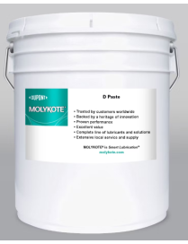
Solid-Lubricant-based paste with the consistency of an NLGI 2-3 Grease, made of a combination of white solid Lubricants and mineral oil.
?
Product Sizes
20.4 kg pail
A mineral-oil-based anti-seize paste formulated with solid lubricants such as white solids - used primarily for assembly and run-in.
LOCTITE? 4601 is a low-odor, low-bloom, (medical device grade) instant adhesive. The low-viscosity adhesive is ideal for applications where odor and/or blooming are a concern. LOCTITE 4601 provides for rapid bonding of metals, elastomers and plastics, including difficult-to-bond plastics (PP, PE, PTFE) when used in conjunction with a primer such as LOCTITE? SF 7701. LOCTITE 4601 is tested to Henkel's ISO 10993 protocols for use in disposable medical devices.
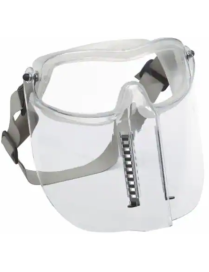
The 3M? Modul-R? Safety Goggles offer extended coverage with an optional impact visor included to help provide additional protection. An open or closed venting system helps minimize fogging and can be flipped up in stand-by position.
Adjustability: Headband pivots for added customization. Adjustable neoprene strap.
Minimizes fog: Specialized venting system lets air in while keeping foreign matter out, minimizing heat and condensation while maximizing protection against airborne debris.
Low profile visor: Attaches directly to goggle and can be flipped up in stand-by position.
The Lion Alcolmeter 500P is a comprehensive solution for alcohol testing and record keeping purposes. The instrument is supplied with a compact and reliable printer in a small and robust carry case. The A500P and its printout will prove to be extremely valuable in disciplinary and CCMA cases.
Non woven swabs of the highest quality 4ply cotton in easy open packaging.
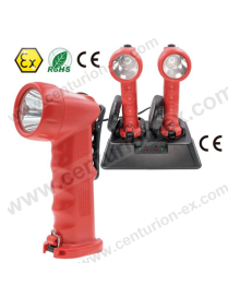
EX-2380 Intrinsically Safe Rescue Hand Lamp (Rechargeable) is ATEX Directive certified for safe use in hazardous locations in zones 1, 2, and zones 21, 22. It provides five output modes, high, medium, low, strobe light, and SOS, which apply to different situations. It's used a high-power LED for excellent light output, up to 120 lumens light output, at the high mode the duration up to 10 hours.
This high-strength hand lamp is exceptionally robust and reliable, proven shockproof, seal lens and end cap, scratch-resistant and chemically resistant glass lens, IP66 waterproof, and dustproof.
The compact, lightweight, and ergonomic hand lamp body give enhanced grip and easy for the user with one hand switch; even wearing gloves, you can also use a high-strength clip for hands-free use.
Unitor FuelPower AshFree is the solution for combustion and deposit issues with VLSFO introduced through IMO 2020. Unitor FuelPower AshFree is formulated to protect against deposit build-up on sensitive engine parts. The product also ensures good combustion to avoid additional build-up of insulating soot deposits.
Product number: 779090
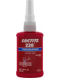
When you have pre-assembled fasteners less than 6.35 mm (1/4") in diameter and need an effective threadlocker that allows for easy disassembly without shearing the screw, choose LOCTITE? 220. This fluorescent, low viscosity threadlocker wicks its away into the thread roots of pre-assembled, small diameter fasteners. Perfect for applications such as adjustment of set screws and small diameter or long engagement length fasteners.
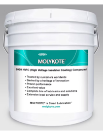
Greaselike silicone coating especially formulated to give electrical insulators long-term resistance to water filming and flashover. Designed to extend service life by maximizing performance in contact with high-voltage corona stress, ultraviolet light, water erosion, and particulate contamination.
?
Product Sizes
4.5 kg pail
22.6 kg pail
NLGI Grade 2-3, charcoal, used primarily as a high voltage insulator coating.
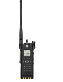
We know the job puts your officers in harm?s way every day. The last thing they need to worry about is safe communication. Certified to the stringent Div1 HazLoc standards, the APX 8000H is designed for use in areas where there are routinely dangerous concentrations of flammable gases, vapors, liquids or combustible dust. The APX 8000H has an adaptive audio engine that provides the provides the loudest, clearest audio at any volume, in any environment.
Of course, communication matters too. Your officers can?t afford not to hear?or be heard at any volume, in any environment. We also know that they need to connect with outside agencies, often without a moment to spare.
Designed for professionals in food, healthcare, and painting, the MODULO PURE slip-on safety shoe features an easy-to-clean, stain-resistant Lorica upper and a non-marking Tiger Grip rubber outsole that offers an extreme level of grip and traction. The rotation circle on the forefoot allows smooth pivots while maintaining grip. Completely metal free and vegan, this shoe combines safety, comfort, and hygiene in one sleek design.
Lead- and nickel-free anti-seize paste used to reduce wear and optimize friction of threaded fasteners, or other metal-to-metal joints, enabling nondestructive dismantling, even after long exposure to high temperatures. It offers good corrosion protection, under high loads, over a wide temperature range.
?
Product Sizes
25 kg pail
?
KEY PROPERTIES
A mineral-oil-based anti-seize paste formulated with solid lubricants such as copper, graphite, and white solids.
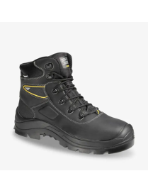
The waterproof BASALT are a perfect blend of style, comfort, and unparalleled safety. These mid-cut safety shoes are robust, full leather and equipped with SR slip resistant soles, ensuring maximum grip on both steel and ceramic surfaces. The heat-resistant outsoles can withstand up to 300?C, making them ideal for high-temperature environments. The ESD feature provides controlled discharge of electrostatic energy, protecting your electronic equipment. Lightweight and metal free, these shoes feature a composite toecap and puncture resistant lightweight midsole for enhanced protection.
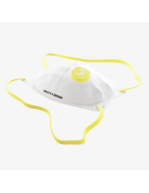
FFP2 mask that provides effective respiratory protection against harmful solid and liquid particles, such as fine dust and oil mist, up to 10 times the workplace limit value. Thanks to the special shape, soft materials and flexible nose bridge, the half mask can be adjusted precisely and seals perfectly. Comes with ear loops and head strap and offers maximum breathability. The additional valve makes breathing pleasantly easy and reduces fatigue during long work sessions.
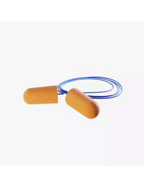
Disposable and slow-recovery foam earplugs that provide comfortable hearing protection. The Arusha plugs protect against loud or permanent noises by reducing the volume to safe levels, even in heavy-duty noise environments. Simply roll the plug into a small cylinder, insert it into the ear and wait for it to expand comfortably in the ear canal. These earplugs are permanently connected by a plastic cord, so they can be worn around the neck when not in use.
?
British Admiralty Nautical Chart 1385 Cotonou to Pennington River is corrected up to date. Admiralty standard nautical charts comply with Safety of Life at Sea (SOLAS) regulations and are ideal for professional, commercial and recreational use. Charts within the series consist of a range of scales, useful for passage planning, ocean crossings, coastal navigation and entering port. Mariners should always use the largest scale nautical chart appropriate to their needs. In particularly busy seaways such as the English Channel, Gulf of Suez and the Malacca and Singapore Straits, the standard nautical charts are supplemented by mariners routeing guides which provide advice on route planning in these complex areas.