- New
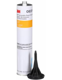
3M™ Aerospace Sealant AC-350 is a family of intermediate density, fast-curing, polysulfide fuel tank sealants that provides outstanding resistance to aviation fuels and petroleum chemicals. Our Class A and B variants maintain bond strength on many metal, composite and coated substrates and help meet a range of applications for integral fuel tank and fuselage sealing.
The 3M™ Aerospace Sealant AC-350 family of polysulfide sealants provide a number of advantages and benefits compared to traditional sealants. With two classes, they meet a wide range of manufacturing and maintenance needs.


 Security policy
(edit with the Customer Reassurance module)
 Delivery policy
(edit with the Customer Reassurance module)
 Return policy
(edit with the Customer Reassurance module)
Application: Sealing
Application Life: 1 Hour, 2 Hour, 4 Minute, 15 Minute, 30 Hour
Brands: 3M
Container Size (Imperial): 0.882 Ounce, 1 Quart, 1 Pint, 1 Ounce, 1 Ounce, 2.5 Ounce, 3.5 Gallon, 5 Ounce, 6 Gallon
Container Size (Metric): 0.059 Liter, 0.104 Liter, 0.473 Liter, 18.927 Liter, 25 g
Cure Type: Fast Cure
Net Weight (Imperial): 0.011 lb
Net Weight (Metric): 25 g
Product Color: Brown
Product Form: Kit
Product Volume: 0.5 Ounce, 2 Ounce, 3.5 Ounce, 4.5 Ounce, 5 Ounce, 12 Gallon, 24 Ounce, 96 Ounce
Sealant Class: A, B


3M™ Aerospace Sealant AC-350 is a family of intermediate density, fast-curing, polysulfide fuel tank sealants that provides outstanding resistance to aviation fuels and petroleum chemicals. Our Class A and B variants maintain bond strength on many metal, composite and coated substrates and help meet a range of applications for integral fuel tank and fuselage sealing.
The 3M™ Aerospace Sealant AC-350 family of polysulfide sealants provide a number of advantages and benefits compared to traditional sealants. With two classes, they meet a wide range of manufacturing and maintenance needs.