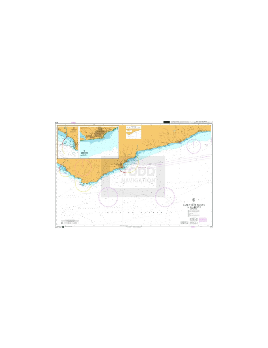


British Admiralty Nautical Chart 3113 Cape Three Points to Saltpond is corrected up to date.
Admiralty standard nautical charts comply with Safety of Life at Sea (SOLAS) regulations and are ideal for professional, commercial and recreational use. Charts within the series consist of a range of scales, useful for passage planning, ocean crossings, coastal navigation and entering port. Mariners should always use the largest scale nautical chart appropriate to their needs. In particularly busy seaways such as the English Channel, Gulf of Suez and the Malacca and Singapore Straits, the standard nautical charts are supplemented by mariners routeing guides which provide advice on route planning in these complex areas.

(edit with the Customer Reassurance module)

(edit with the Customer Reassurance module)

(edit with the Customer Reassurance module)
Main Chart Details
Chart Title: Cape Three Points to Saltpond
Publication Date: 04/06/1982
Latest Edition date: 06/06/2019
Chart Size: 1000 x 639 (mm)
Chart Panel Details
Panel Name: Cape Three Points to Saltpond
Natural Scale: 150000
North Limit 5: 15'.17N
East Limit 0: 58'.39W
South Limit 4: 23'.16N
West Limit 2: 19'.53W
Panel Name A: Axim Bay
Natural Scale: 50000
North Limit 4: 55'.16N
East Limit 2: 14'.07W
South Limit 4: 49'.72N
West Limit 2: 17'.58W
Panel Name B: Cape Coast Anchorage
Natural Scale: 12000
North Limit 5: 06'.68N
East Limit 1: 13'.78W
South Limit 5: 05'.37N
West Limit 1: 15'.39W
Panel Name C: Elmina Bay
Natural Scale: 15000
North Limit 5: 05'.20N
East Limit 1: 20'.10W
South Limit 5: 04'.30N
West Limit 1: 21'.20W

The Safety Jogger MANAGER is an elegant safety shoe offering exceptional protection and designed for the modern worker. This shoe takes safety to a new level with its SR slip-resistant soles, perfect for both steel and ceramic surfaces. The MANAGER is equipped with ESD for controlled electrostatic discharge, ensuring your safety around electronic components. Its composite toecap is metal-free and lightweight, providing superior comfort without compromising on safety. The shoe's oil and fuel resistant outsole and SJ Flex puncture resistant material make it perfect for high-risk environments.
A drug testing method where a single sample is divided into two specimens one for initial screening and the other retained for confirmation or retesting ensuring accuracy, transparency, and defensible results in workplace and regulated testing programs.
Product Sizes
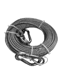
A heat- and flame-resistant lifeline designed for firefighting and emergency rescue operations. With a 5 mm diameter and 30 m length, it features a secure hook for dependable attachment, ensuring safety, strength, and durability in high-temperature environments.
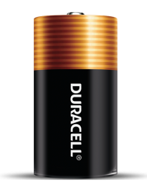
Get dependable, long lasting Coppertop batteries. These batteries have been engineered to deliver the life you need for your suitable, everyday devices.
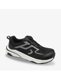
Free your toes with the FREEDOM S1PS LOW TLS. Engineered to move with you, the anatomically shaped toe cap supports your foot?s natural biomechanics. It gives you space to breathe, flex and flow - just as nature intended - all while keeping you protected. The advanced eTPU/rubber outsole delivers exceptional slip resistance on both dry and extremely slippery surfaces, while the metal-free, anti-puncture midsole provides lightweight protection without sacrificing durability. With the Twist Lock System you can tighten your safety shoes in a flash.
Solid lubricating paste with particularly low friction coefficient for assembly and running-in of metallic components.
Product Sizes
A mineral oil based anti-seize paste formulated with solid lubricants such as molybdenum disulfide, graphite, and white solids.
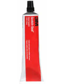
3M? Scotch-Seal? Metal Sealant 2084 is a one-part aluminum colored, general purpose, medium viscosity sealer that air dries to a tough, flexible film that resists water, oils and fuel. The sealant has a strong, reliable internal integrity after full cure.
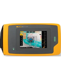
The Fluke ii500 Acoustic Imager, equipped with LeakQ? technology, empowers maintenance teams to detect and locate gas leaks efficiently. Designed for ease of use, it requires no specialized training. Even during peak production periods, teams can effectively identify gas and vacuum leaks. The ii500's advanced acoustic leak detection technology isolates leak sound frequencies, making leaks visible even in noisy environments.
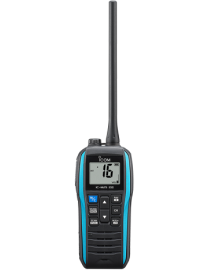
The IC-M25EURO EVO is an upgraded model of the extremely popular IC-M25EURO floating VHF marine handheld transceiver. The IC-M25EURO EVO is designed with an improved grip texture for easier handling, and larger buttons for easier operation. Moreover, it has adopted a new power-saving Eco Mode which will allow approximately about 14 hours of operation, which is about a 30% improvement. Furthermore, a USB Type-C? charging port is standard. The IC-M25EURO EVO still retains its compact and lightweight body, and industry leading Float'n Flash? and submersible design.
The SD 400 comes in a protective pouch and carry case which contains a portable printer and charger making it easy to obtain immediate printed evidence wherever the test is conducted.
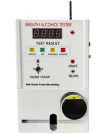
AT319, Standby Breath Alcohol Tester, is designed to measure alcohol concentration of peole. With advanced fuel cell alcohol sensor module, this device has excellent sensitivity and reproducibility. Reasonable and easy testing process, complete function makes it versatile in many public occasions, such as club, bars, hotel and restaurant.
A Class A AIS transceiver designed for commercial and professional vessels, delivering high-performance AIS transmission and reception. The ComNav X5 enhances situational awareness, collision avoidance, and maritime safety, meeting international maritime requirements.
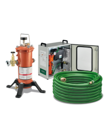
With a simple exhaust valve and easy-to-replace filter cartridge, the CPF unit provides clean, fresh air to the operator indefinitely.
The easy-to-handle CPF air filter can be deployed for mobile or stationary use and can filter air for up to four operators simultaneously. Painted safety orange, the cartridge is clearly visible on a work site.
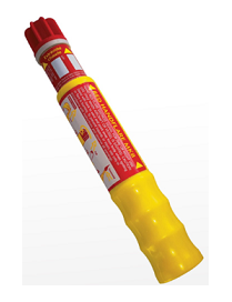
Red hand-held, short range distress signal. Used to pinpoint location by day or night. Burns for 60 seconds at 15,000 candela. Features a unique telescopic handle making it very compact and space saving when stowed in a liferaft. Easily extended and pull wire operated.
Transform from APR to PAPR
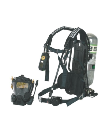
This air mask provides uniquely versatile protection, transforming quickly from a CBRN self-contained breathing apparatus to either an air-purifying respirator (APR) or a powered air-purifying respirator (PAPR). Easily goes from first response and rescue to scene management and remediation. This mask features a one-way inhalation check valve, wide-view lens with Kevlar SpeeD-ON? head harness and high-performance mechanical diaphragm. As the first and only of its kind, it provides emergency responders with the maximum level of protection in CBRN environments
British Admiralty Nautical Chart 3113 Cape Three Points to Saltpond is corrected up to date.
Admiralty standard nautical charts comply with Safety of Life at Sea (SOLAS) regulations and are ideal for professional, commercial and recreational use. Charts within the series consist of a range of scales, useful for passage planning, ocean crossings, coastal navigation and entering port. Mariners should always use the largest scale nautical chart appropriate to their needs. In particularly busy seaways such as the English Channel, Gulf of Suez and the Malacca and Singapore Straits, the standard nautical charts are supplemented by mariners routeing guides which provide advice on route planning in these complex areas.