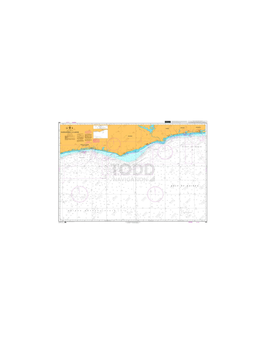


British Admiralty Nautical Chart 595 Sassandra to Lagos is corrected up to date.?
Admiralty standard nautical charts comply with Safety of Life at Sea (SOLAS) regulations and are ideal for professional, commercial and recreational use. Charts within the series consist of a range of scales, useful for passage planning, ocean crossings, coastal navigation and entering port. Mariners should always use the largest scale nautical chart appropriate to their needs. In particularly busy seaways such as the English Channel, Gulf of Suez and the Malacca and Singapore Straits, the standard nautical charts are supplemented by mariners routeing guides which provide advice on route planning in these complex areas.

(edit with the Customer Reassurance module)

(edit with the Customer Reassurance module)

(edit with the Customer Reassurance module)
Chart INT. 2087
Main Chart Details
Chart Title: Sassandra to Lagos
Publication Date: 08/04/1994
Latest Edition date: 18/03/2010
Chart Size: 1100 x 749 (mm)
Chart Panel Details
Panel Name: Sassandra to Lagos
Natural Scale: 1000000
North Limit 6: 57'.00N
East Limit 3: 45'.00E
South Limit 0: 10'.00N
West Limit 6: 10'.00W

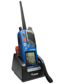
The Tron TR30 AIR Emergency VHF AM radio is delivered complete with a sealed emergency battery, test battery, hand strap and a holder for the radio and battery. The robust design more than meets the typical maritime requirements.
The added advantage with this radio is that it floats with either battery. An innovative noise cancelling microphone filters background noise and includes a high output loudspeaker. This combination provides clearer communication with Air search and rescue services in extreme environments.
The Tron TR30 AIR radio handset can be used with several optional waterproof speaker-microphone accessories for hands-free use during noisy aircraft operations.
Heat-curing dry-film Lubricant
?
Product Sizes
18 liter pail
A heat-cured anti-friction coating filled with solid lubricants in an organic binder.
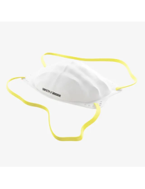
The Stora FFP2 mask provides effective respiratory protection against harmful solid and liquid particles, such as fine dust and oil mist, up to 10 times the workplace limit value. Thanks to its special shape, soft materials and flexible nose bridge, the half mask can be adjusted precisely and seals perfectly. Comes with ear loops and a head strap and offers maximum breathability.
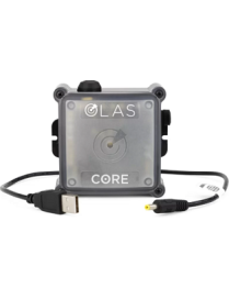
The Core is a compact, portable overboard alarm and emergency light system. It reacts within 2 seconds of a person falling overboard and can easily be switched between vessels without the time and cost of wired installation. The Core can connect with up to 25 OLAS transmitters and cover a vessel up to 50ft.
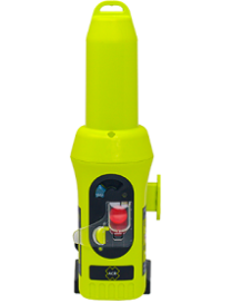
Stay safe at sea with the Pathfinder? PRO Search and Rescue Transponder (SART). This SART complies with IMO SOLAS regulations, and has a superior lithium battery that provides over 96 hours of operating life in standby mode, and 12 hours of active operating life. The compact Pathfinder PRO comes with a sleek wall mount that keeps it out of your way, yet readily accessible in the event of an emergency. A SART is mandatory for all commercial vessels that must conform to GMDSS, and any vessel carrying more than one life raft.
Fully fluorinated grease provides extraordinary performance under extreme conditions
?
Product Sizes
100 g bottle - 20 per carton
500 g bottle - 10 per carton
NLGI Grade 2 - Linear PFPE based grease with a base oil viscosity of 160 cSt at 40 C, PTFE thickened, uses PTFE as solid lubricants.
HP-300 Grease has been tested by BAM and approved for the use in oxygen rich environments e.g. in pumps, valves, compressors. The test results ensure that HP-300 Grease is safe and stable when exposed to oxygen under high pressure and elevated temperatures e.g. under 50 bars at 60 ?C or 10 bars at 300 ?C.
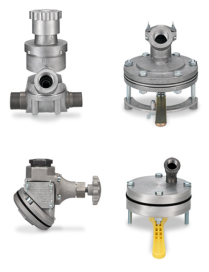
Clemco-produced abrasive metering valves are constructed of high-quality, abrasive-resistant components and can suit all abrasive medias. The manual and pneumatically-controlled valves from Clemco have proven their value a thousand times over in every application. Clemco media valves dispense abrasive in an even, regulated flow, offsetting irregularities during pressurization and depressurization, making for consistent ease of use. Pneumatic controls respond far more quickly than manual ones, increasing operator safety through immediate start/stop control of the blast stream. The ?fail-to-safe? feature of control handle release ensures that, should the operator drop the blast hose or encounter any other problems, the blast stream stops immediately.
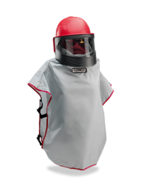
With the Apollo 600, Clemco has produced the newest generation of operator protective helmets. Utilizing tried-and-true features from past generations of Clemco blast helmets, every last detail of the new Apollo has been refined to present the final word in operator comfort and protection. The Apollo 600 combines increased safety and protection with enhanced comfort, easy functionality and a longer lifetime..
The flexible size adjustment options of the helmet, combined with replaceable, washable inner material, ensures the perfect fit for any operator. The optional DLX insert is available to provide additional padding for a heightened degree of comfort and acoustic protection.
APX NEXT XN is NFPA1802 certified to bring unprecedented durability and mobilized intelligence to a firefighter?s lifeline so you can outperform whatever the day throws at you.
MOTOTRBO? R7 offers loud clear audio up to 107 phons, up to 28 hours long battery runtime, built-in Wi-Fi and Bluetooth, GPS location and a rugged IP68 waterproof casing to connect your workforce, helping boost efficiency, productivity and safety.
A cost-effective single-gas detector with a superior lifespan
Designed for superior lifespan and high performance, with patented sensors that operate for over two years, the ALTAIR Single-Gas Detector is the smart choice for market-leading, cost-effective gas monitors. These units feature sensor options for carbon monoxide, hydrogen sulfide, and oxygen, coupled with LED/audible/vibrating alarms. Superior dust/water protection, high RFI resistance, and one-button operation provide heightened safety, plus increased durability and ease-of-use.
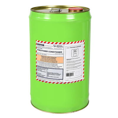
Unitor FuelPower Catalyst improves combustion and make sure the fuel is stable and homogeneous when injected into the engine. Reducing soot will keep the engine and exhaust gas boiler clean. Unitor FuelPower Catalyst works with conventional HSFO and VLSFO introduced through IMO 2020.
Product number: 779096
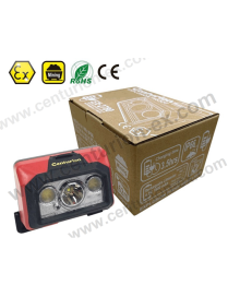
This EX-2780 Intrinsically Safe Head Light (Rechargeable) is ATEX Directive certified for safe use in hazardous locations in zones 1 & 2 and zones 21, 22. IP66 waterproof and dustproof.
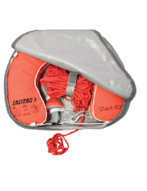
1 Horseshoe Lifebuoy ?Quick RD? (code 70164)
1 Lifebuoy Light (code 71325)
30 m floating rope, ? 8 mm, orange
1 horseshoe case made of durable PVC (code 72330)
Can be mounted on handrails
*Lifebuoy Light 70030 (not included) can also fit into the case
Refill of the ARUSHA plugs: disposable and slow-recovery foam earplugs that provide comfortable hearing protection. The Arusha plugs protect against loud or permanent noises by reducing the volume to safe levels, even in heavy-duty noise environments. Simply roll the plug into a small cylinder, insert it into the ear and wait for it to expand comfortably in the ear canal. Incredibly soft & anti-allergic.
Disposable breath sampling straws specifically designed for the Alcoblow rapid alcohol screening device, ensuring hygienic use, accurate results, and efficient high-volume testing.
British Admiralty Nautical Chart 595 Sassandra to Lagos is corrected up to date.?
Admiralty standard nautical charts comply with Safety of Life at Sea (SOLAS) regulations and are ideal for professional, commercial and recreational use. Charts within the series consist of a range of scales, useful for passage planning, ocean crossings, coastal navigation and entering port. Mariners should always use the largest scale nautical chart appropriate to their needs. In particularly busy seaways such as the English Channel, Gulf of Suez and the Malacca and Singapore Straits, the standard nautical charts are supplemented by mariners routeing guides which provide advice on route planning in these complex areas.