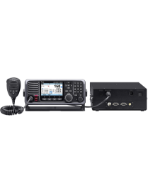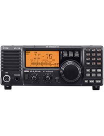
ICOM IC-78
HF TRANSCEIVER Reliable Long Distance Communications
Powerful 100 W output provides the talk power you need to reach distant locations. Its one-piece, die-cast aluminum construction provides stabilityeven at high duty cycles.


Personal safety is the practice of protecting yourself from situations that could cause harm or danger. It involves being aware of your surroundings, recognizing potential risks, and taking steps to prevent accidents or threats. Personal safety covers many areas, including home security, online safety, travel awareness, and self-defense.
Marine safety is the discipline concerned with safeguarding life, property, and the marine environment from the dangers associated with maritime activities. It involves the implementation of international and national laws, safety standards, and operational procedures aimed at preventing accidents such as collisions, fires, and shipwrecks. Key aspects include vessel design and maintenance, crew training, navigation safety, emergency preparedness, and pollution prevention.
Organizations such as the International Maritime Organization (IMO) set global standards for ship safety, pollution control, and seafarer training through conventions like the SOLAS (Safety of Life at Sea) and MARPOL (Marine Pollution) treaties. Marine safety also covers the use of safety equipment (e.g., life jackets, lifeboats, distress signals), adherence to navigation rules, and the management of hazardous materials onboard ships.
Ultimately, marine safety ensures that maritime operations are conducted responsibly and efficiently, protecting human lives, marine ecosystems, and the economic interests tied to global shipping and ocean use.
Choosing the right industrial supplier can make all the difference in performance, safety, and efficiency. Ceesea Safety limited is committed to helping businesses across industries minimize downtime and maximize productivity. Explore our catalog or contact our team today to get a custom quote for your industrial supply needs
Instrumentation and Digital Devices is a field dedicated to the design, development, and application of advanced instruments and systems that measure, control, and automate industrial and scientific processes. Our focus is on integrating precision hardware with intelligent digital technologies to enhance efficiency, accuracy, and performance across diverse sectors.
At Ceesea Safety Ltd, we provide top-quality medical supplies and equipment trusted by healthcare professionals, clinics, and individuals. From diagnostic tools and wound care products to mobility aids and personal protective equipment, our wide selection ensures safety, reliability, and comfort. We?re committed to excellence, fast delivery, and exceptional customer service?because your health deserves the best.
Welcome to Ceesea Safety Limited, your trusted source for high-quality tools and industrial machinery. We specialize in providing durable, reliable, and performance-driven equipment for construction, manufacturing, automotive, and workshop needs. Whether you?re a professional tradesperson or a DIY enthusiast, our wide range of tools ensures precision, power, and productivity for every job.
Active filters
HF TRANSCEIVER Reliable Long Distance Communications
Powerful 100 W output provides the talk power you need to reach distant locations. Its one-piece, die-cast aluminum construction provides stabilityeven at high duty cycles.
If in an emergency situation, press the large independent Distress button to send an automated digital Distress signal. The digital distress signal with GPS coordinates calls for help from other ships or coast stations.
The dedicated DSC watch-keeping receiver continuously scans the six distress channels in rotation. A total of 100 MMSI numbers (75 Individual and 25 Group) for DSC calls can be stored with a 10-character ID name. When you receive a DSC call, while you are in process with another DSC call, the IC-M803 can hold both DSC procedures to switch between the DSC calls with the Multiple Task Mode function.
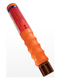
Particularly suitable for yachts, dinghies and sailboards, this water resistant, hand- held signal produces a dense orange smoke for daylight distress signalling and wind direction indication.
The NEW Comet 3 Minute Smoke Signal Orange is a compact, flat top, daytime distress signal designed to be easy and safe to handle. It provides effective position marking during rescue operations and can be used to indicate wind direction, producing dense orange smoke for a minimum of 3 minutes.
The Smoke Signal Orange is a compact, daylight distress signal designed to be easy and safe to handle. It provides effective position marking during rescue operations and can be used to indicate wind direction, producing dense orange smoke for a minimum of 3 minutes.
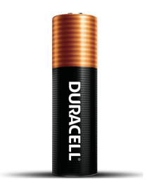
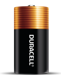
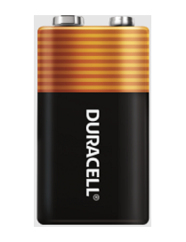
Duracell Coppertop AA and AAA alkaline batteries contain Duracell's patented POWER BOOST? Ingredients which deliver lasting performance in your devices.
Get dependable, long lasting Coppertop batteries. These batteries have been engineered to deliver the life you need for your suitable, everyday devices.
Get dependable, long lasting Coppertop batteries. These batteries have been engineered to deliver the life you need for your suitable, everyday devices.
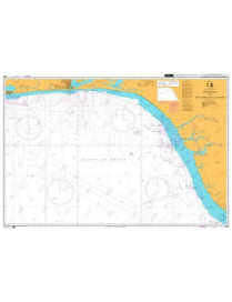
British Admiralty Nautical Chart 1321 Ports and Terminals in the Gulf of Guinea. This nautical chart complies with Safety of Life at Sea (SOLAS) regulations and is ideal for professional, commercial and recreational use. Charts within the series consist of a range of scales, useful for passage planning, ocean crossings, coastal navigation and entering port.
Mariners should always use the largest scale nautical chart appropriate to their needs. In particularly busy seaways such as the English Channel, Gulf of Suez and the Malacca and Singapore Straits, the standard nautical charts are supplemented by mariners routing guides which provide advice on route planning in these complex areas
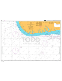
British Admiralty Nautical Chart 3288: Nigeria, Bonny River, Ford Point to Port Harcourt is a standard nautical chart. This nautical chart complies with Safety of Life at Sea (SOLAS) regulations and is ideal for professional, commercial and recreational use. Charts within the series consist of a range of scales, useful for passage planning, ocean crossings, coastal navigation and entering port.
Mariners should always use the largest scale nautical chart appropriate to their needs. In particularly busy seaways such as the English Channel, Gulf of Suez and the Malacca and Singapore Straits, the standard nautical charts are supplemented by mariners routeing guides which provide advice on route planning in these complex areas.
British Admiralty Nautical Chart 1387 Calabar to Bata including Isla de Bioko is corrected up to date.
Admiralty standard nautical charts comply with Safety of Life at Sea (SOLAS) regulations and are ideal for professional, commercial and recreational use. Charts within the series consist of a range of scales, useful for passage planning, ocean crossings, coastal navigation and entering port. Mariners should always use the largest scale nautical chart appropriate to their needs. In particularly busy seaways such as the English Channel, Gulf of Suez and the Malacca and Singapore Straits, the standard nautical charts are supplemented by mariners routeing guides which provide advice on route planning in these complex areas.
British Admiralty Nautical Chart 1385 Cotonou to Pennington River is corrected up to date. Admiralty standard nautical charts comply with Safety of Life at Sea (SOLAS) regulations and are ideal for professional, commercial and recreational use. Charts within the series consist of a range of scales, useful for passage planning, ocean crossings, coastal navigation and entering port. Mariners should always use the largest scale nautical chart appropriate to their needs. In particularly busy seaways such as the English Channel, Gulf of Suez and the Malacca and Singapore Straits, the standard nautical charts are supplemented by mariners routeing guides which provide advice on route planning in these complex areas.
British Admiralty Nautical Chart 1386 Pennington River to Opobo River is corrected up to date.
Admiralty standard nautical charts comply with Safety of Life at Sea (SOLAS) regulations and are ideal for professional, commercial and recreational use. Charts within the series consist of a range of scales, useful for passage planning, ocean crossings, coastal navigation and entering port. Mariners should always use the largest scale nautical chart appropriate to their needs. In particularly busy seaways such as the English Channel, Gulf of Suez and the Malacca and Singapore Straits, the standard nautical charts are supplemented by mariners routing guides which provide advice on route planning in these complex areas.
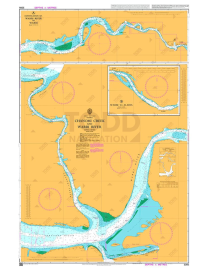
British Admiralty Nautical Chart 3305 Chanomi Creek and Warri River is corrected up to date.
Admiralty standard nautical charts comply with Safety of Life at Sea (SOLAS) regulations and are ideal for professional, commercial and recreational use. Charts within the series consist of a range of scales, useful for passage planning, ocean crossings, coastal navigation and entering port. Mariners should always use the largest scale nautical chart appropriate to their needs. In particularly busy seaways such as the English Channel, Gulf of Suez and the Malacca and Singapore Straits, the standard nautical charts are supplemented by mariners routeing guides which provide advice on route planning in these complex areas.
British Admiralty Nautical Chart 3432 Saltpond to Tema is corrected up to date.
Admiralty standard nautical charts comply with Safety of Life at Sea (SOLAS) regulations and are ideal for professional, commercial and recreational use. Charts within the series consist of a range of scales, useful for passage planning, ocean crossings, coastal navigation and entering port. Mariners should always use the largest scale nautical chart appropriate to their needs. In particularly busy seaways such as the English Channel, Gulf of Suez and the Malacca and Singapore Straits, the standard nautical charts are supplemented by mariners routeing guides which provide advice on route planning in these complex areas.
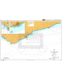
British Admiralty Nautical Chart 3113 Cape Three Points to Saltpond is corrected up to date.
Admiralty standard nautical charts comply with Safety of Life at Sea (SOLAS) regulations and are ideal for professional, commercial and recreational use. Charts within the series consist of a range of scales, useful for passage planning, ocean crossings, coastal navigation and entering port. Mariners should always use the largest scale nautical chart appropriate to their needs. In particularly busy seaways such as the English Channel, Gulf of Suez and the Malacca and Singapore Straits, the standard nautical charts are supplemented by mariners routeing guides which provide advice on route planning in these complex areas.
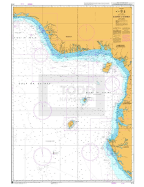
British Admiralty Nautical Chart 3118 Lagos to Gamba is corrected up to date.
Admiralty standard nautical charts comply with Safety of Life at Sea (SOLAS) regulations and are ideal for professional, commercial and recreational use. Charts within the series consist of a range of scales, useful for passage planning, ocean crossings, coastal navigation and entering port. Mariners should always use the largest scale nautical chart appropriate to their needs. In particularly busy seaways such as the English Channel, Gulf of Suez and the Malacca and Singapore Straits, the standard nautical charts are supplemented by mariners routeing guides which provide advice on route planning in these complex areas.
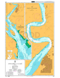
British Admiralty Nautical Chart 3433 Approaches to Calabar Sheet 1 is corrected up to date.
Admiralty standard nautical charts comply with Safety of Life at Sea (SOLAS) regulations and are ideal for professional, commercial and recreational use. Charts within the series consist of a range of scales, useful for passage planning, ocean crossings, coastal navigation and entering port. Mariners should always use the largest scale nautical chart appropriate to their needs. In particularly busy seaways such as the English Channel, Gulf of Suez and the Malacca and Singapore Straits, the standard nautical charts are supplemented by mariners routeing guides which provide advice on route planning in these complex areas.
The red parachute rocket is used for long-range distress signaling on ships, lifeboats and life rafts. When activated, it launches a signal flare to attract the attention of rescuers.
The launching tube features clear instructions for use, and its non-slip surface ensures safe operation even when you launch it with one hand. The parachute flare is waterproof and can be held underwater when fired.
Introduced in 1959, the parachute flare has a design that is now used by most manufacturers around the world. As the leader of the market, it meets the highest demands for quality, performance, functionality, and safe operation. It has been approved globally and conforms to the latest SOLAS regulations.
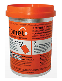
The handheld orange smoke is a marine flare designed to give maximum output from a minimum size container.
The orange handsmoke is a daytime distress flare and an excellent choice for your leisure boat. The denced smoke also shows the wind direction. This orange hand smoke is, as all of our products, is easy to use and comes with clear instructions.
The orange handheld flare is CE approved and tested for the Australian Standard.
ADMIRALTY Chart - 3434 Approaches to Calabar, Sheet 2 is corrected up to date.
Admiralty standard nautical charts comply with Safety of Life at Sea (SOLAS) regulations and are ideal for professional, commercial and recreational use. Charts within the series consist of a range of scales, useful for passage planning, ocean crossings, coastal navigation and entering port. Mariners should always use the largest scale nautical chart appropriate to their needs. In particularly busy seaways such as the English Channel, Gulf of Suez and the Malacca and Singapore Straits, the standard nautical charts are supplemented by mariners routeing guides which provide advice on route planning in these complex areas.