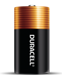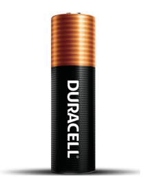
DURACELL Coppertop Battery AA
Duracell Coppertop AA and AAA alkaline batteries contain Duracell's patented POWER BOOST? Ingredients which deliver lasting performance in your devices.


Personal safety is the practice of protecting yourself from situations that could cause harm or danger. It involves being aware of your surroundings, recognizing potential risks, and taking steps to prevent accidents or threats. Personal safety covers many areas, including home security, online safety, travel awareness, and self-defense.
Marine safety is the discipline concerned with safeguarding life, property, and the marine environment from the dangers associated with maritime activities. It involves the implementation of international and national laws, safety standards, and operational procedures aimed at preventing accidents such as collisions, fires, and shipwrecks. Key aspects include vessel design and maintenance, crew training, navigation safety, emergency preparedness, and pollution prevention.
Organizations such as the International Maritime Organization (IMO) set global standards for ship safety, pollution control, and seafarer training through conventions like the SOLAS (Safety of Life at Sea) and MARPOL (Marine Pollution) treaties. Marine safety also covers the use of safety equipment (e.g., life jackets, lifeboats, distress signals), adherence to navigation rules, and the management of hazardous materials onboard ships.
Ultimately, marine safety ensures that maritime operations are conducted responsibly and efficiently, protecting human lives, marine ecosystems, and the economic interests tied to global shipping and ocean use.
Choosing the right industrial supplier can make all the difference in performance, safety, and efficiency. Ceesea Safety limited is committed to helping businesses across industries minimize downtime and maximize productivity. Explore our catalog or contact our team today to get a custom quote for your industrial supply needs
Instrumentation and Digital Devices is a field dedicated to the design, development, and application of advanced instruments and systems that measure, control, and automate industrial and scientific processes. Our focus is on integrating precision hardware with intelligent digital technologies to enhance efficiency, accuracy, and performance across diverse sectors.
At Ceesea Safety Ltd, we provide top-quality medical supplies and equipment trusted by healthcare professionals, clinics, and individuals. From diagnostic tools and wound care products to mobility aids and personal protective equipment, our wide selection ensures safety, reliability, and comfort. We?re committed to excellence, fast delivery, and exceptional customer service?because your health deserves the best.
Welcome to Ceesea Safety Limited, your trusted source for high-quality tools and industrial machinery. We specialize in providing durable, reliable, and performance-driven equipment for construction, manufacturing, automotive, and workshop needs. Whether you?re a professional tradesperson or a DIY enthusiast, our wide range of tools ensures precision, power, and productivity for every job.
Active filters
Duracell Coppertop AA and AAA alkaline batteries contain Duracell's patented POWER BOOST? Ingredients which deliver lasting performance in your devices.
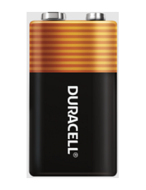
Get dependable, long lasting Coppertop batteries. These batteries have been engineered to deliver the life you need for your suitable, everyday devices.
Get dependable, long lasting Coppertop batteries. These batteries have been engineered to deliver the life you need for your suitable, everyday devices.
British Admiralty Nautical Chart 1385 Cotonou to Pennington River is corrected up to date. Admiralty standard nautical charts comply with Safety of Life at Sea (SOLAS) regulations and are ideal for professional, commercial and recreational use. Charts within the series consist of a range of scales, useful for passage planning, ocean crossings, coastal navigation and entering port. Mariners should always use the largest scale nautical chart appropriate to their needs. In particularly busy seaways such as the English Channel, Gulf of Suez and the Malacca and Singapore Straits, the standard nautical charts are supplemented by mariners routeing guides which provide advice on route planning in these complex areas.
British Admiralty Nautical Chart 1386 Pennington River to Opobo River is corrected up to date.
Admiralty standard nautical charts comply with Safety of Life at Sea (SOLAS) regulations and are ideal for professional, commercial and recreational use. Charts within the series consist of a range of scales, useful for passage planning, ocean crossings, coastal navigation and entering port. Mariners should always use the largest scale nautical chart appropriate to their needs. In particularly busy seaways such as the English Channel, Gulf of Suez and the Malacca and Singapore Straits, the standard nautical charts are supplemented by mariners routing guides which provide advice on route planning in these complex areas.
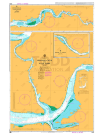
British Admiralty Nautical Chart 3305 Chanomi Creek and Warri River is corrected up to date.
Admiralty standard nautical charts comply with Safety of Life at Sea (SOLAS) regulations and are ideal for professional, commercial and recreational use. Charts within the series consist of a range of scales, useful for passage planning, ocean crossings, coastal navigation and entering port. Mariners should always use the largest scale nautical chart appropriate to their needs. In particularly busy seaways such as the English Channel, Gulf of Suez and the Malacca and Singapore Straits, the standard nautical charts are supplemented by mariners routeing guides which provide advice on route planning in these complex areas.
British Admiralty Nautical Chart 3432 Saltpond to Tema is corrected up to date.
Admiralty standard nautical charts comply with Safety of Life at Sea (SOLAS) regulations and are ideal for professional, commercial and recreational use. Charts within the series consist of a range of scales, useful for passage planning, ocean crossings, coastal navigation and entering port. Mariners should always use the largest scale nautical chart appropriate to their needs. In particularly busy seaways such as the English Channel, Gulf of Suez and the Malacca and Singapore Straits, the standard nautical charts are supplemented by mariners routeing guides which provide advice on route planning in these complex areas.
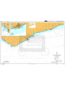
British Admiralty Nautical Chart 3113 Cape Three Points to Saltpond is corrected up to date.
Admiralty standard nautical charts comply with Safety of Life at Sea (SOLAS) regulations and are ideal for professional, commercial and recreational use. Charts within the series consist of a range of scales, useful for passage planning, ocean crossings, coastal navigation and entering port. Mariners should always use the largest scale nautical chart appropriate to their needs. In particularly busy seaways such as the English Channel, Gulf of Suez and the Malacca and Singapore Straits, the standard nautical charts are supplemented by mariners routeing guides which provide advice on route planning in these complex areas.
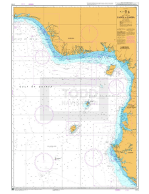
British Admiralty Nautical Chart 3118 Lagos to Gamba is corrected up to date.
Admiralty standard nautical charts comply with Safety of Life at Sea (SOLAS) regulations and are ideal for professional, commercial and recreational use. Charts within the series consist of a range of scales, useful for passage planning, ocean crossings, coastal navigation and entering port. Mariners should always use the largest scale nautical chart appropriate to their needs. In particularly busy seaways such as the English Channel, Gulf of Suez and the Malacca and Singapore Straits, the standard nautical charts are supplemented by mariners routeing guides which provide advice on route planning in these complex areas.
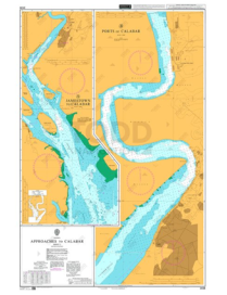
British Admiralty Nautical Chart 3433 Approaches to Calabar Sheet 1 is corrected up to date.
Admiralty standard nautical charts comply with Safety of Life at Sea (SOLAS) regulations and are ideal for professional, commercial and recreational use. Charts within the series consist of a range of scales, useful for passage planning, ocean crossings, coastal navigation and entering port. Mariners should always use the largest scale nautical chart appropriate to their needs. In particularly busy seaways such as the English Channel, Gulf of Suez and the Malacca and Singapore Straits, the standard nautical charts are supplemented by mariners routeing guides which provide advice on route planning in these complex areas.
ADMIRALTY Chart - 3434 Approaches to Calabar, Sheet 2 is corrected up to date.
Admiralty standard nautical charts comply with Safety of Life at Sea (SOLAS) regulations and are ideal for professional, commercial and recreational use. Charts within the series consist of a range of scales, useful for passage planning, ocean crossings, coastal navigation and entering port. Mariners should always use the largest scale nautical chart appropriate to their needs. In particularly busy seaways such as the English Channel, Gulf of Suez and the Malacca and Singapore Straits, the standard nautical charts are supplemented by mariners routeing guides which provide advice on route planning in these complex areas.
British Admiralty Nautical Chart 3286 Approaches to Bonny River is corrected up to date.
Admiralty standard nautical charts comply with Safety of Life at Sea (SOLAS) regulations and are ideal for professional, commercial and recreational use. Charts within the series consist of a range of scales, useful for passage planning, ocean crossings, coastal navigation and entering port. Mariners should always use the largest scale nautical chart appropriate to their needs. In particularly busy seaways such as the English Channel, Gulf of Suez and the Malacca and Singapore Straits, the standard nautical charts are supplemented by mariners routeing guides which provide advice on route planning in these complex areas.
High capacity petroleum sorbents have a scrim on one side to increase strength and help eliminate linting. Rolls of sorbent material are used to cover and sorb large spills or in areas where spills may occur.
Designed to cover large surfaces, can be easily placed in tight areas. Ideal for cleaning-up small spills and wiping down contaminated areas. They can be cut to the desired length and are one of the most economical ways to purchase sorbent. The HP-100 roll sorbs 73 gallons per roll and is 38 inches by 144 feet long.
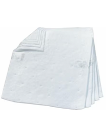
High capacity petroleum sorbents have a scrim on one side to increase strength and help eliminate linting. Conveniently sized pads allow the user to quickly spread sorbent over and in the path of a spill.
This high capacity, low profile Sorbent pad, picks up petroleum based fluids, will not absorb water. For routine use, cleaning up small spills and wiping contaminated areas. Pads may also be used on a work surface in anticipation of a spill or as a wipe. 100 pads (19 inch X 17 inch) per bale, (37.5 gallons/bale).
This petroleum sorbent boom is a double boom 10 feet long with two 4 inches scrim encased tubes of particulate sorbent material secured by a UV resistant netting.
Petroleum sorbent pillows are designed with a scrim that encases particulate sorbent material. Pillows are used in areas where more capacity is desired than can easily be achieved using a sorbent pad.
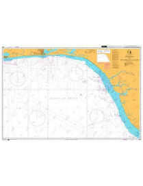
British Admiralty Nautical Chart 595 Sassandra to Lagos is corrected up to date.?
Admiralty standard nautical charts comply with Safety of Life at Sea (SOLAS) regulations and are ideal for professional, commercial and recreational use. Charts within the series consist of a range of scales, useful for passage planning, ocean crossings, coastal navigation and entering port. Mariners should always use the largest scale nautical chart appropriate to their needs. In particularly busy seaways such as the English Channel, Gulf of Suez and the Malacca and Singapore Straits, the standard nautical charts are supplemented by mariners routeing guides which provide advice on route planning in these complex areas.
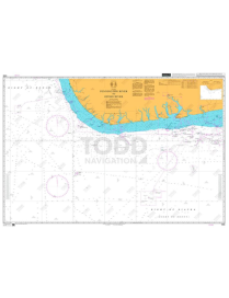
British Admiralty Nautical Chart 3321 Entrances to Escravos and Forcados Rivers is corrected up to date.?
Admiralty standard nautical charts comply with Safety of Life at Sea (SOLAS) regulations and are ideal for professional, commercial and recreational use. Charts within the series consist of a range of scales, useful for passage planning, ocean crossings, coastal navigation and entering port. Mariners should always use the largest scale nautical chart appropriate to their needs. In particularly busy seaways such as the English Channel, Gulf of Suez and the Malacca and Singapore Straits, the standard nautical charts are supplemented by mariners routeing guides which provide advice on route planning in these complex areas.
MSA ALTAIR 5X Gas Detector measures up to 6 gases including natural gas and is now available with a PID Detector
The ALTAIR 5X Gas Detector is capable of measuring up to 6 gases simultaneously and is now available with integrated PID sensor for VOC detection. Driven by advanced MSA XCell? Sensor Technology, the ALTAIR 5X Gas Detector delivers faster response time, better stability, accuracy, longer service life, and cost savings over the life of the instrument.
The MSA ALTAIR? 4XR Multigas Detector is a rugged and reliable personnel gas monitor, outfitted with rapid-response MSA XCell? sensors, the ALTAIR 4XR Gas Detector is the toughest 4-gas monitor in the market and is backed by a 4-year warranty for sensor which each calibration duration lasting for every 6-six month.