Subcategories

  • Personal Safety

    Personal safety is the practice of protecting yourself from situations that could cause harm or danger. It involves being aware of your surroundings, recognizing potential risks, and taking steps to prevent accidents or threats. Personal safety covers many areas, including home security, online safety, travel awareness, and self-defense.

  • Marine Safety and...

    Marine safety is the discipline concerned with safeguarding life, property, and the marine environment from the dangers associated with maritime activities. It involves the implementation of international and national laws, safety standards, and operational procedures aimed at preventing accidents such as collisions, fires, and shipwrecks. Key aspects include vessel design and maintenance, crew training, navigation safety, emergency preparedness, and pollution prevention.

    Organizations such as the International Maritime Organization (IMO) set global standards for ship safety, pollution control, and seafarer training through conventions like the SOLAS (Safety of Life at Sea) and MARPOL (Marine Pollution) treaties. Marine safety also covers the use of safety equipment (e.g., life jackets, lifeboats, distress signals), adherence to navigation rules, and the management of hazardous materials onboard ships.

    Ultimately, marine safety ensures that maritime operations are conducted responsibly and efficiently, protecting human lives, marine ecosystems, and the economic interests tied to global shipping and ocean use.

  • Industrial safety

    Choosing the right industrial supplier can make all the difference in performance, safety, and efficiency. Ceesea Safety limited is committed to helping businesses across industries minimize downtime and maximize productivity. Explore our catalog or contact our team today to get a custom quote for your industrial supply needs

  • Instrumentation and...

    Instrumentation and Digital Devices is a field dedicated to the design, development, and application of advanced instruments and systems that measure, control, and automate industrial and scientific processes. Our focus is on integrating precision hardware with intelligent digital technologies to enhance efficiency, accuracy, and performance across diverse sectors.

  • Medical Safety

    At Ceesea Safety Ltd, we provide top-quality medical supplies and equipment trusted by healthcare professionals, clinics, and individuals. From diagnostic tools and wound care products to mobility aids and personal protective equipment, our wide selection ensures safety, reliability, and comfort. We?re committed to excellence, fast delivery, and exceptional customer service?because your health deserves the best.

  • Tools and Machinery

    Welcome to Ceesea Safety Limited, your trusted source for high-quality tools and industrial machinery. We specialize in providing durable, reliable, and performance-driven equipment for construction, manufacturing, automotive, and workshop needs. Whether you?re a professional tradesperson or a DIY enthusiast, our wide range of tools ensures precision, power, and productivity for every job.

Active filters

  • Brand: ACR Electronics
  • Brand: ADMIRALTY
  • Brand: Fluke
  • Brand: Red Wing Shoe Company
  • Brand: RKI Instruments
  • Brand: ZOLL

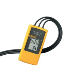
Fluke 9040 Phase Rotation Indicator

The Fluke 9040 is effective for measuring phase rotation in all areas where three phase supplies are used to feed motors, drives and electrical systems. The Fluke 9040 is a rotary field indicator and can provide clear indication of the 3 phase via an LCD display and the phase rotation direction to determine correct connections. It allows rapid determination of phase sequence and has a voltage (up to 700 V) and frequency range suitable for commercial and industrial applications. The included test probes have a variable clamping range for safe contact, also in industrial sockets.

Fluke 2AC Non-Contact Voltage Tester

Always on for faster, safer voltage testing

The Fluke 2AC is the latest addition to the VoltAlert? AC non-contact voltage tester family. It is designed to be pocket-sized and easy to use. The tip of the pocket-sized tester will glow red when within close proximity of an outlet, terminal strip, or power cord where voltage is present. The 2 AC is always on, with a battery check function to make sure the tester is working properly.

Fluke T+Pro Electrical Tester

Safer than solenoid testers and fully compliant with NFPA 70E, (when used properly per Article 110.4 Use of Equipment (A) Test Instruments and Equipment), the T+Pro helps electricians and technicians work safer by indicating the presence of voltage, even when the batteries are dead. Additional functionality, such as a GFCI trip, easy to read LCD screen, resistance measurement up to 9.99 k?, and a built-in flashlight make the T+Pro the first voltage tester that electricians reach for.

How to use the Fluke T+ Pro Electrical Tester

The Fluke T+Pro Electrical Tester indicated AC/DC voltage in three different ways:

  • Light
  • Sound
  • Vibration

Fluke iSee? Mobile Thermal Camera - TC01A/TC01B/TC01C

Experience fast and easy inspections on the go with Fluke iSee? Mobile Thermal Camera, weighing just 22g. It takes only a second to start using. The wide temperature measurement range, up to 550?C (1022?F), makes it suitable for various applications, including inspecting electrical cabinets, identifying HVAC issues, and installing underfloor heating. Fluke iSee boasts professional-grade image quality, comparable to high-end thermal cameras, with a 256 x 192 pixel thermal resolution and smooth video recording at a 25 Hz frame rate. Additionally, our software offers comprehensive spot, line, and area temperature analysis for precise diagnostics.

Fluke TiS55+ Thermal Camera

With so many inspections in your day, it can be hard to remember what you saw and where that was. Maybe you carry around a clipboard to jot down notes onto. The TiS55+ comes with built-in personal assistants, which means you can finally ditch the clipboard and have all the information you need in the images you take, including:

Voice annotation

Record up to 60 seconds per thermal image

Identify exactly what you see in real time

IR-PhotoNotes

Take photos of asset numbers and other identifiers

Use as a reference when looking at the thermal image on your computer

Asset Tagging

Sort your thermal images by asset

Scan a QR code on your asset, then start capturing thermal images

Connect your camera to your computer to view the images, sorted by asset

Fluke TiX580 Infrared Camera

Sometimes the infrared images you need to capture are the ones that are almost impossible to take. With a full 180-degree articulating lens and 5.7 inch touchscreen, the Fluke TiX580 Infrared Camera allows thermographers to easily navigate over, under, and around objects to preview and capture images with ease. The cameras are ideal for predictive maintenance, R&D, oil and gas, and utility applications where flexibility and higher resolution are essential.

Fluke Ti401 PRO Thermal Camera

Every day you work hard to get the job done. Fluke gets that. For over 70 years, we have worked with people in the industrial trades. We understand that you need thermal imagers that will get the job done; rugged general use, every day thermal imagers that are easy to use, accurate and create high quality images. The Fluke Ti401 PRO is exactly this type of camera. It is an ideal camera for certified or uncertified thermographers working in:

  • industrial maintenance
  • heavy commercial facility maintenance
  • commercial building diagnostics

Fluke ii915 Acoustic Imager

The Fluke ii915 Acoustic Imager is a powerful tool designed to identify and evaluate issues in various systems. With three distinct modes?LeakQ?, PDQ?, and MecQ??this innovative device empowers maintenance professionals to take proactive measures and prevent costly problems.

British Admiralty Nautical Chart 1321 Ports and Terminals in the Gulf of Guinea

British Admiralty Nautical Chart 1321 Ports and Terminals in the Gulf of Guinea. This nautical chart complies with Safety of Life at Sea (SOLAS) regulations and is ideal for professional, commercial and recreational use. Charts within the series consist of a range of scales, useful for passage planning, ocean crossings, coastal navigation and entering port.


Mariners should always use the largest scale nautical chart appropriate to their needs. In particularly busy seaways such as the English Channel, Gulf of Suez and the Malacca and Singapore Straits, the standard nautical charts are supplemented by mariners routing guides which provide advice on route planning in these complex areas

ADMIRALTY Chart - 3288 Bonny River, Ford Point to Port Harcourt

British Admiralty Nautical Chart 3288: Nigeria, Bonny River, Ford Point to Port Harcourt is a standard nautical chart. This nautical chart complies with Safety of Life at Sea (SOLAS) regulations and is ideal for professional, commercial and recreational use. Charts within the series consist of a range of scales, useful for passage planning, ocean crossings, coastal navigation and entering port.


Mariners should always use the largest scale nautical chart appropriate to their needs. In particularly busy seaways such as the English Channel, Gulf of Suez and the Malacca and Singapore Straits, the standard nautical charts are supplemented by mariners routeing guides which provide advice on route planning in these complex areas.

British Admiralty Nautical Chart 1387 Calabar to Bata including Isla de Bioko

British Admiralty Nautical Chart 1387 Calabar to Bata including Isla de Bioko is corrected up to date.


Admiralty standard nautical charts comply with Safety of Life at Sea (SOLAS) regulations and are ideal for professional, commercial and recreational use. Charts within the series consist of a range of scales, useful for passage planning, ocean crossings, coastal navigation and entering port. Mariners should always use the largest scale nautical chart appropriate to their needs. In particularly busy seaways such as the English Channel, Gulf of Suez and the Malacca and Singapore Straits, the standard nautical charts are supplemented by mariners routeing guides which provide advice on route planning in these complex areas.

British Admiralty Nautical Chart 1385 Cotonou to Pennington River

British Admiralty Nautical Chart 1385 Cotonou to Pennington River is corrected up to date. Admiralty standard nautical charts comply with Safety of Life at Sea (SOLAS) regulations and are ideal for professional, commercial and recreational use. Charts within the series consist of a range of scales, useful for passage planning, ocean crossings, coastal navigation and entering port. Mariners should always use the largest scale nautical chart appropriate to their needs. In particularly busy seaways such as the English Channel, Gulf of Suez and the Malacca and Singapore Straits, the standard nautical charts are supplemented by mariners routeing guides which provide advice on route planning in these complex areas.

British Admiralty Nautical Chart 1386 Pennington River to Opobo River

British Admiralty Nautical Chart 1386 Pennington River to Opobo River is corrected up to date.


Admiralty standard nautical charts comply with Safety of Life at Sea (SOLAS) regulations and are ideal for professional, commercial and recreational use. Charts within the series consist of a range of scales, useful for passage planning, ocean crossings, coastal navigation and entering port. Mariners should always use the largest scale nautical chart appropriate to their needs. In particularly busy seaways such as the English Channel, Gulf of Suez and the Malacca and Singapore Straits, the standard nautical charts are supplemented by mariners routing guides which provide advice on route planning in these complex areas.

British Admiralty Nautical Chart 3305 Chanomi Creek and Warri River

British Admiralty Nautical Chart 3305 Chanomi Creek and Warri River is corrected up to date.

Admiralty standard nautical charts comply with Safety of Life at Sea (SOLAS) regulations and are ideal for professional, commercial and recreational use. Charts within the series consist of a range of scales, useful for passage planning, ocean crossings, coastal navigation and entering port. Mariners should always use the largest scale nautical chart appropriate to their needs. In particularly busy seaways such as the English Channel, Gulf of Suez and the Malacca and Singapore Straits, the standard nautical charts are supplemented by mariners routeing guides which provide advice on route planning in these complex areas.

British Admiralty Nautical Chart 3432 Saltpond to Tema

British Admiralty Nautical Chart 3432 Saltpond to Tema is corrected up to date.

Admiralty standard nautical charts comply with Safety of Life at Sea (SOLAS) regulations and are ideal for professional, commercial and recreational use. Charts within the series consist of a range of scales, useful for passage planning, ocean crossings, coastal navigation and entering port. Mariners should always use the largest scale nautical chart appropriate to their needs. In particularly busy seaways such as the English Channel, Gulf of Suez and the Malacca and Singapore Straits, the standard nautical charts are supplemented by mariners routeing guides which provide advice on route planning in these complex areas.

British Admiralty Nautical Chart 3113 Cape Three Points to Saltpond

British Admiralty Nautical Chart 3113 Cape Three Points to Saltpond is corrected up to date.

Admiralty standard nautical charts comply with Safety of Life at Sea (SOLAS) regulations and are ideal for professional, commercial and recreational use. Charts within the series consist of a range of scales, useful for passage planning, ocean crossings, coastal navigation and entering port. Mariners should always use the largest scale nautical chart appropriate to their needs. In particularly busy seaways such as the English Channel, Gulf of Suez and the Malacca and Singapore Straits, the standard nautical charts are supplemented by mariners routeing guides which provide advice on route planning in these complex areas.

British Admiralty Nautical Chart 3118 Lagos to Gamba

British Admiralty Nautical Chart 3118 Lagos to Gamba is corrected up to date.

Admiralty standard nautical charts comply with Safety of Life at Sea (SOLAS) regulations and are ideal for professional, commercial and recreational use. Charts within the series consist of a range of scales, useful for passage planning, ocean crossings, coastal navigation and entering port. Mariners should always use the largest scale nautical chart appropriate to their needs. In particularly busy seaways such as the English Channel, Gulf of Suez and the Malacca and Singapore Straits, the standard nautical charts are supplemented by mariners routeing guides which provide advice on route planning in these complex areas.

British Admiralty Nautical Chart 3433 Approaches to Calabar Sheet 1

British Admiralty Nautical Chart 3433 Approaches to Calabar Sheet 1 is corrected up to date.

Admiralty standard nautical charts comply with Safety of Life at Sea (SOLAS) regulations and are ideal for professional, commercial and recreational use. Charts within the series consist of a range of scales, useful for passage planning, ocean crossings, coastal navigation and entering port. Mariners should always use the largest scale nautical chart appropriate to their needs. In particularly busy seaways such as the English Channel, Gulf of Suez and the Malacca and Singapore Straits, the standard nautical charts are supplemented by mariners routeing guides which provide advice on route planning in these complex areas.

British Admiralty Nautical Chart 3434 Approaches to Calabar Sheet 2

ADMIRALTY Chart - 3434 Approaches to Calabar, Sheet 2 is corrected up to date.

Admiralty standard nautical charts comply with Safety of Life at Sea (SOLAS) regulations and are ideal for professional, commercial and recreational use. Charts within the series consist of a range of scales, useful for passage planning, ocean crossings, coastal navigation and entering port. Mariners should always use the largest scale nautical chart appropriate to their needs. In particularly busy seaways such as the English Channel, Gulf of Suez and the Malacca and Singapore Straits, the standard nautical charts are supplemented by mariners routeing guides which provide advice on route planning in these complex areas.

British Admiralty Nautical Chart 3286 Approaches to Bonny River

British Admiralty Nautical Chart 3286 Approaches to Bonny River is corrected up to date.

Admiralty standard nautical charts comply with Safety of Life at Sea (SOLAS) regulations and are ideal for professional, commercial and recreational use. Charts within the series consist of a range of scales, useful for passage planning, ocean crossings, coastal navigation and entering port. Mariners should always use the largest scale nautical chart appropriate to their needs. In particularly busy seaways such as the English Channel, Gulf of Suez and the Malacca and Singapore Straits, the standard nautical charts are supplemented by mariners routeing guides which provide advice on route planning in these complex areas.